
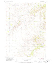
1954 Map of Star
USGS Topo · Published 1956About this map
The small community of Star sits at the heart of this mid-century survey along the border of Holt and Knox counties. This corner of Nebraska is defined by the branching waters of Verdigre Creek, including the North Branch and Middle Branch, which carve through the landscape of Steel Creek, Washington, Willowdale, and Walnut Grove townships. Local family roots can be traced through several rural institutions and landmarks, such as the Cedar Corner School and School No 45. To the southeast, the Grimton School and nearby Grimton Cemetery represent the social and civic hubs of a dispersed ranching and farming community. Numerous windmills and isolated section-line roads speak to the agricultural nature of the region during the 1950s development of the Missouri River Basin.
Find a feature on this map
17 named features on this map. Tap any name to fly to it.
Don’t see what you’re looking for? This feature index may not catch every label — zoom into the map to look around manually.
Map Details
Editions of this 1954 Star Map
2 editions found
Other maps of this area

1950 · Dorsey NW
USGS Topo · 1:24,000

1950 · Pishelville
USGS Topo · 1:24,000

1952 · Dorsey
USGS Topo · 1:24,000

1954 · Walnut
USGS Topo · 1:24,000

1954 · Dorsey SW
USGS Topo · 1:24,000

1955 · O'Neill
USGS Topo · 1:250,000

1958 · Page
USGS Topo · 1:24,000

1959 · O'Neill
USGS Topo · 1:250,000

1963 · Venus
USGS Topo · 1:24,000
1963 · Orchard NW
USGS Topo · 1:24,000