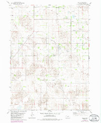
1981 Map of Amelia
USGS Topo · Published 1986About this map
The unincorporated settlement of Amelia serves as the focal point for this 1980s Nebraska landscape, where the South Fork Elkhorn River winds through the northern sections of the quadrangle. The terrain is defined by its hydrology and agricultural layout, featuring numerous Flowing Wells and the intermittent path of Dry Creek. Cultural landmarks are centered around rural community life, notably the Bethany Ch located south of the main river fork. The map details a network of section lines, fences, and field boundaries, many updated from 1984 aerial photography, reflecting the land use patterns in Holt County during this era. This survey provides a clear view of the area's transition from riparian zones to upland fields, documented during a period of photorevised mapping.
Find a feature on this map
8 named features on this map. Tap any name to fly to it.
Don’t see what you’re looking for? This feature index may not catch every label — zoom into the map to look around manually.
Map Details
Editions of this 1981 Amelia Map
2 editions found
Other maps of this area

1955 · O'Neill
USGS Topo · 1:250,000

1959 · O'Neill
USGS Topo · 1:250,000

1964 · Emmet SE
USGS Topo · 1:24,000

1964 · Emmet SW
USGS Topo · 1:24,000

1969 · O'Neill
USGS Topo · 1:250,000
1981 · Abbott Ranch
USGS Topo · 1:24,000

1981 · Swan Lake
USGS Topo · 1:24,000

1981 · Amelia
USGS Topo · 1:24,000
1981 · Miles Ranch
USGS Topo · 1:24,000
1981 · Chain Lake
USGS Topo · 1:24,000