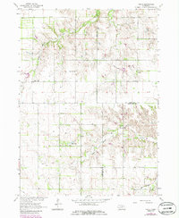
1963 Map of Venus
USGS Topo · Published 1986About this map
Verdigre Creek branches carve through this rural landscape at the junction of Holt, Knox, and Antelope Counties in the early 1960s. The settlement of Venus serves as a small focal point, supported by local education landmarks like the Venus Sch and the more remote Cream Ridge Sch. This area of Nebraska is defined by a traditional township grid where scattered rural schools, including School No 55 and School No 30, mark the intersection of section lines. The topography transitions from the drainage basins of the Middle Branch Verdigre Creek to unique local features such as Saltz Lake and the winding Big Springs Creek. Genealogists may find value in the location of the Lambert Cem, situated in a quiet section of the quadrangle north of the Antelope County line.
Find a feature on this map
14 named features on this map. Tap any name to fly to it.
Don’t see what you’re looking for? This feature index may not catch every label — zoom into the map to look around manually.
Map Details
Editions of this 1963 Venus Map
2 editions found
Other maps of this area

1954 · Walnut
USGS Topo · 1:24,000

1954 · Dorsey SW
USGS Topo · 1:24,000

1954 · Star
USGS Topo · 1:24,000

1955 · O'Neill
USGS Topo · 1:250,000

1958 · Page
USGS Topo · 1:24,000

1959 · O'Neill
USGS Topo · 1:250,000

1963 · Ewing SW
USGS Topo · 1:24,000

1963 · Venus
USGS Topo · 1:24,000

1963 · Orchard
USGS Topo · 1:24,000

1963 · Ewing
USGS Topo · 1:24,000