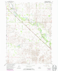
1963 Map of Ewing SW
USGS Topo · Published 1986About this map
The Elkhorn River meanders across this Holt County landscape, defining the topography of the Missouri River Basin during the mid-1960s. The settlement of Stafford serves as a central point along the diagonal route of the Chicago and North Western railroad, which cuts sharply across the prairie. The map reveals a land shaped by water and transit, where the river's path is flanked by oxbows and marshy features such as Learys Lakes and Chain Lakes. This survey, updated with 1980s photographic revisions, documents a rural Nebraska environment focused on the intersection of natural drainage systems and late-nineteenth-century rail infrastructure. Local historians can observe the fine-grained elevation changes and the specific placement of the rail line relative to the seasonal waters of the Elkhorn.
Find a feature on this map
7 named features on this map. Tap any name to fly to it.
Don’t see what you’re looking for? This feature index may not catch every label — zoom into the map to look around manually.
Map Details
Editions of this 1963 Ewing SW Map
2 editions found
Other maps of this area

1955 · O'Neill
USGS Topo · 1:250,000

1958 · Inman
USGS Topo · 1:24,000

1958 · Page
USGS Topo · 1:24,000

1959 · O'Neill
USGS Topo · 1:250,000

1963 · Ewing SW
USGS Topo · 1:24,000

1963 · Venus
USGS Topo · 1:24,000

1963 · Ewing
USGS Topo · 1:24,000

1963 · Deloit NE
USGS Topo · 1:24,000

1963 · Deloit NW
USGS Topo · 1:24,000

1964 · O'Neill SE
USGS Topo · 1:24,000