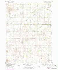
1981 Map of Chambers West
USGS Topo · Published 1986About this map
South Fork Elkhorn River winds through the northern sections of this Holt County landscape, defining a terrain shaped by its hydrology. The eastern edge of the survey focuses on the village of Chambers, where the local Fairground and a nearby Cem indicate a centered community life during the mid-1980s. A defining characteristic of this region is the abundance of groundwater, evidenced by the numerous Flowing Wells and additional wells scattered across the grid. These features highlight the importance of the Ogallala Aquifer to the local agricultural economy. The map also includes detailed photographic revisions of woodland areas and fence lines, offering a precise view of land use and property boundaries in this portion of the Nebraska sandhills region during this period.
Find a feature on this map
8 named features on this map. Tap any name to fly to it.
Don’t see what you’re looking for? This feature index may not catch every label — zoom into the map to look around manually.
Map Details
Editions of this 1981 Chambers West Map
2 editions found
Other maps of this area

1955 · O'Neill
USGS Topo · 1:250,000

1959 · O'Neill
USGS Topo · 1:250,000

1964 · Emmet SE
USGS Topo · 1:24,000

1964 · Emmet SW
USGS Topo · 1:24,000

1964 · O'Neill SW
USGS Topo · 1:24,000

1969 · O'Neill
USGS Topo · 1:250,000

1981 · Amelia
USGS Topo · 1:24,000

1981 · Goose Lake SW
USGS Topo · 1:24,000

1981 · Chambers East
USGS Topo · 1:24,000
1981 · Miles Ranch
USGS Topo · 1:24,000