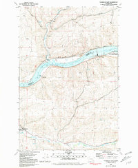
1981 Map of Starbuck East
USGS Topo · Published 1981About this map
The Lake Herbert G West Snake River dominates this landscape along the border of Whitman and Columbia counties, shaped by the industrial presence of the Little Goose Lock and Dam. The town of Starbuck sits in the southwest corner near the Tucannon River, where grain storage facilities and rail infrastructure reflect the region's agricultural foundations. Throughout the valley, several Grain Elevators and Storage Bins are situated along the Union Pacific line, indicating the importance of transport for local harvests. In the north, the terrain transitions into the high Camas Prairie and the drainage of Alkali Flat Creek. Former crossing points and river landings are noted at Riparia and Texas Rapids, which by this era had been adapted into recreational sites like the Riparia Launch Area.
Find a feature on this map
29 named features on this map. Tap any name to fly to it.
Don’t see what you’re looking for? This feature index may not catch every label — zoom into the map to look around manually.
Map Details
Editions of this 1981 Starbuck East Map
This is the sole edition of this map. No revisions or reprints were ever made.
Other maps of this area

1919 · Walla Walla
USGS Topo · 1:125,000

1921 · Walla Walla
USGS Topo · 1:125,000

1937 · Pomeroy
USGS Topo · 1:96,000

1942 · Pomeroy
USGS Topo · 1:125,000

1948 · Starbuck
USGS Topo · 1:62,500

1950 · Starbuck
USGS Topo · 1:62,500

1950 · Hay
USGS Topo · 1:62,500

1952 · Hay
USGS Topo · 1:62,500

1953 · Walla Walla
USGS Topo · 1:250,000

1955 · Pullman
USGS Topo · 1:250,000