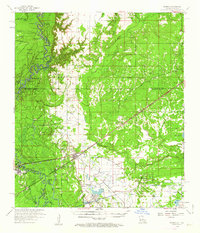
1959 Map of Starks
USGS Topo · Published 1963About this map
The Sabine River forms a complex boundary between Louisiana and Texas, creating a dense network of oxbows and backwaters such as Horseshoe Lake, Mims Lake, and the wetland maze of Devils Pocket. In this late 1950s landscape, the town of Starks serves as a local hub along the Kansas City Southern railroad, which cuts a straight path southwest through the heart of the terrain. The presence of the Starks Oil Field and scattered gas wells indicates the region's industrial ties to petroleum extraction, while a Lookout Tower and a series of levees point to the ongoing management of this low-lying, water-dominated environment.
Find a feature on this map
68 named features on this map. Tap any name to fly to it.
Don’t see what you’re looking for? This feature index may not catch every label — zoom into the map to look around manually.
Map Details
Editions of this 1959 Starks Map
3 editions found
Other maps of this area

1926 · Mauriceville
USGS Topo · 1:24,000

1932 · Orange
USGS Topo · 1:62,500

1943 · Mauriceville
USGS Topo · 1:24,000

1947 · Sulphur
USGS Topo · 1:31,680

1947 · Starks
USGS Topo · 1:31,680

1947 · Vinton
USGS Topo · 1:31,680

1947 · Toomey
USGS Topo · 1:31,680

1947 · Carter Creek
USGS Topo · 1:31,680

1947 · DeQuincy
USGS Topo · 1:31,680

1947 · Sulphur Mines
USGS Topo · 1:31,680