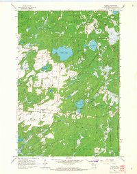
1965 Map of Starks
USGS Topo · Published 1966About this map
Glacial lakes and marshy lowlands dominate this mid-century view of Oneida County, where the settlement of Starks sits at the junction of the east-west Soo Line and the north-south Chicago and North Western railroads. This transportation corridor served a landscape defined by water and forest, notably featuring the expansive Stella Lake and the smaller Ginty Lake. Social life centered on landmarks like the Stella Sch and a local Townhall, while the presence of several Gravel Pit sites near Gagen points to the area's geological and industrial utility. The survey illustrates a transition from the wilder marshes of Gudegast Creek to the organized township boundaries of Stella, Three Lakes, and Piehl, showing how the railroad and early road networks shaped the development of these Northwoods communities.
Find a feature on this map
27 named features on this map. Tap any name to fly to it.
Don’t see what you’re looking for? This feature index may not catch every label — zoom into the map to look around manually.
Map Details
Editions of this 1965 Starks Map
2 editions found
Other maps of this area

1928 · Three Lakes
USGS Topo · 1:48,000

1930 · Robbins
USGS Topo · 1:48,000

1938 · Three Lakes
USGS Topo · 1:48,000

1938 · Robbins
USGS Topo · 1:48,000

1940 · Monico
USGS Topo · 1:48,000

1940 · Rhinelander
USGS Topo · 1:48,000

1945 · Three Lakes
USGS Topo · 1:48,000

1945 · Robbins
USGS Topo · 1:48,000

1949 · Rhinelander
USGS Topo · 1:48,000

1950 · Monico
USGS Topo · 1:48,000