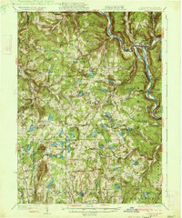
1933 Map of Starrucca
USGS Topo · Published 1933About this map
Hancock sits at a major transit nexus where the West Branch Delaware River meets the heavy rail infrastructure of the early 20th century. This 1933 edition highlights a landscape defined by its complex topography and the competing interests of three major rail lines, including the Erie Railroad and the New York Ontario and Western RR. The terrain of Preston and Scott townships is dotted with numerous small water bodies like Lake Como and Poyntelle Lake, alongside high points such as Mount Ararat and Sugarloaf Mtn.
Find a feature on this map
136 named features on this map. Tap any name to fly to it.
Don’t see what you’re looking for? This feature index may not catch every label — zoom into the map to look around manually.
Map Details
Editions of this 1933 Starrucca Map
3 editions found

Other maps of this area

1892 · Honesdale
USGS Topo · 1:62,500

1892 · Dundaff
USGS Topo · 1:62,500

1905 · Nineveh
USGS Topo · 1:62,500

1920 · Long Eddy
USGS Topo · 1:62,500

1920 · Damascus
USGS Topo · 1:62,500

1921 · Long Eddy
USGS Topo · 1:48,000

1923 · Damascus
USGS Topo · 1:62,500

1923 · Long Eddy
USGS Topo · 1:62,500

1923 · Walton
USGS Topo · 1:48,000

1924 · Starrucca
USGS Topo · 1:48,000