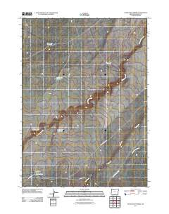
2011 Map of Starvation Spring
USGS Topo · Published 2011About this map
Lucky Seven Cow Camp and its namesake Lucky Seven Reservoir anchor this 2011 survey of Malheur County, Oregon. The landscape is defined by the ephemeral water management of the high desert, where a series of catchments like High Ridge Reservoir, Rocky Road Reservoir, and Goat Creek Reservoir suggest a territory shaped by ranching and seasonal grazing requirements. Below High Ridge, the drainage network follows the Big Antelope Creek as it makes the Upper Bend Big Antelope Creek. The southeastern corner shows the terrain deepening along Field Creek and Steer Canyon Creek. Transport is limited to specialized routes including Pole Creek Rd and Lucky 7 Cow Camp Rd, which converge near the vital water source at Starvation Spring.
Find a feature on this map
13 named features on this map. Tap any name to fly to it.
Don’t see what you’re looking for? This feature index may not catch every label — zoom into the map to look around manually.
Map Details
Editions of this 2011 Starvation Spring Map
This is the sole edition of this map. No revisions or reprints were ever made.
Other maps of this area

1955 · Jordan Valley
USGS Topo · 1:250,000

1957 · Jordan Valley
USGS Topo · 1:250,000

1958 · Jordan Valley
USGS Topo · 1:250,000

1982 · Rattlesnake Canyon
USGS Topo · 1:24,000
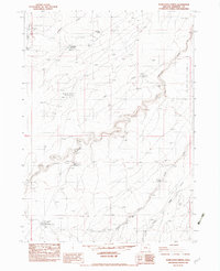
1982 · Starvation Spring
USGS Topo · 1:24,000
1982 · Peacock Lake
USGS Topo · 1:24,000

1982 · Guadalupe Meadows
USGS Topo · 1:24,000
1982 · Grasshopper Flat North
USGS Topo · 1:24,000
1982 · Rawhide Springs
USGS Topo · 1:24,000
1982 · No Crossing Crossing
USGS Topo · 1:24,000