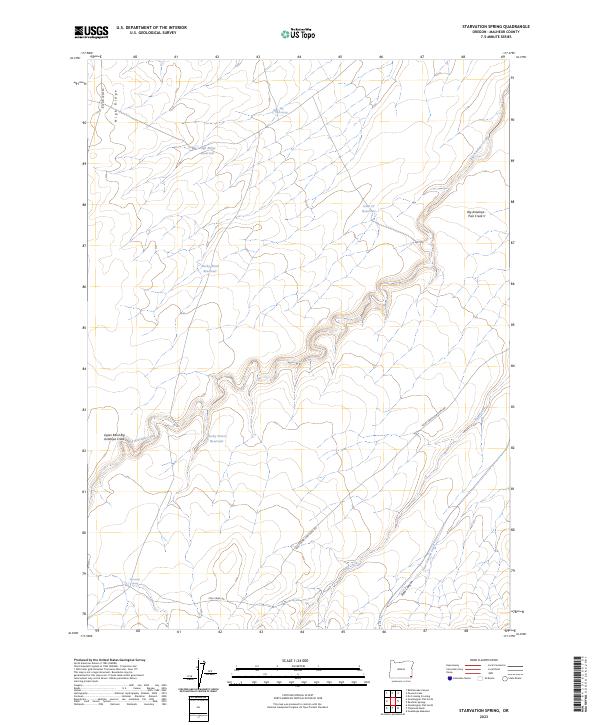
2023 Map of Starvation Spring
USGS Topo · Published 2023About this map
Starvation Spring and Allen Spring provide rare water sources in this high-desert landscape of eastern Oregon. The terrain is defined by a network of drainage systems and isolated water catchments essential for ranching, including the High Ridge Reservoir and Lucky Seven Reservoir. Local livestock operations are further evidenced by the naming of the Lucky Seven Cow Camp Rd, which provides access through the winding topography of Steer Canyon and across Steer Canyon Creek. The elevation is dominated by High Ridge to the west, while the eastern portion of the map follows the deeply carved path of Big Antelope Creek. This 2023 survey illustrates the continued reliance on scattered springs and man-made reservoirs to manage the arid environment for seasonal cattle grazing.
Find a feature on this map
22 named features on this map. Tap any name to fly to it.
Don’t see what you’re looking for? This feature index may not catch every label — zoom into the map to look around manually.
Map Details
Editions of this 2023 Starvation Spring Map
This is the sole edition of this map. No revisions or reprints were ever made.
Other maps of this area

1955 · Jordan Valley
USGS Topo · 1:250,000

1957 · Jordan Valley
USGS Topo · 1:250,000

1958 · Jordan Valley
USGS Topo · 1:250,000

1982 · Rattlesnake Canyon
USGS Topo · 1:24,000
1982 · Starvation Spring
USGS Topo · 1:24,000
1982 · Peacock Lake
USGS Topo · 1:24,000

1982 · Guadalupe Meadows
USGS Topo · 1:24,000
1982 · Grasshopper Flat North
USGS Topo · 1:24,000
1982 · Rawhide Springs
USGS Topo · 1:24,000
1982 · No Crossing Crossing
USGS Topo · 1:24,000