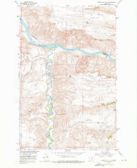
1953 Map of Starve Out Flat
USGS Topo · Published 1976About this map
The Missouri River carves a deep, winding path through this North-Central Montana landscape, serving as the primary geographic divider between Chouteau and Fergus Counties. This 1953 survey, conducted as part of the Department of the Interior's development program for the Missouri River Basin, captures the region's dramatic topography of flat-topped mesas and deep coulees. High ground is dominated by extensive plateaus such as Eightmile Bench and Missouri Bench, which drop sharply toward the river valley. The confluence of the river with Arrow Creek marks a significant hydrological junction, while the lower elevations are defined by expansive alluvial areas like Starve Out Flat and Sneath Bottom. Human presence is sparse, represented by isolated landmarks such as Cow Camp Spring and a rugged Jeep Trail, illustrating the remote ranching character of the high plains during the mid-20th century.
Find a feature on this map
24 named features on this map. Tap any name to fly to it.
Don’t see what you’re looking for? This feature index may not catch every label — zoom into the map to look around manually.
Map Details
Editions of this 1953 Starve Out Flat Map
2 editions found
Other maps of this area

1953 · Starve Out Flat
USGS Topo · 1:24,000

1953 · Last Chance Bench
USGS Topo · 1:24,000

1954 · P N Ranch
USGS Topo · 1:24,000

1954 · Iliad
USGS Topo · 1:24,000

1954 · Dark Butte
USGS Topo · 1:24,000

1954 · Lewistown
USGS Topo · 1:250,000

1959 · Lewistown
USGS Topo · 1:250,000

1964 · Wolf Creek Falls
USGS Topo · 1:24,000

1964 · Pigtail Coulee
USGS Topo · 1:24,000

1964 · Spring Coulee
USGS Topo · 1:24,000