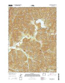
2014 Map of Starvout Creek
USGS Topo · Published 2014About this map
Starvout Creek and Cow Creek anchor this drainage basin along the Douglas and Jackson County line. The landscape is defined by the steep elevation changes between Patrick Mtn and Green Mtn, with numerous drainages like Whitehorse Creek and Quartz Cr cutting through the terrain. Evidence of land management is prominent, with various Bureau of Land Management routes such as BLM-31-4-27 and BLM-32-4-9 providing access to the higher ridges and timbered slopes. This network of forestry roads, including Hogum Creek Rd and Fizzleout Creek Rd, suggests a region focused on resource extraction and back-country navigation. Local history is reflected in named geographic features such as Benjamin Gulch, Booth Gulch, and Hauck Ranch Rd, which point to early settlement and ranching efforts in these isolated valleys.
Find a feature on this map
60 named features on this map. Tap any name to fly to it.
Don’t see what you’re looking for? This feature index may not catch every label — zoom into the map to look around manually.
Map Details
Editions of this 2014 Starvout Creek Map
This is the sole edition of this map. No revisions or reprints were ever made.
Other maps of this area

1904 · Riddle
USGS Topo · 1:125,000

1954 · Days Creek
USGS Topo · 1:62,500

1954 · Glendale
USGS Topo · 1:62,500

1954 · Wimer
USGS Topo · 1:62,500

1954 · Canyonville
USGS Topo · 1:62,500

1955 · Medford
USGS Topo · 1:250,000

1957 · Medford
USGS Topo · 1:250,000

1958 · Medford
USGS Topo · 1:250,000
1983 · Skeleton Mtn
USGS Topo · 1:24,000
1983 · King Mountain
USGS Topo · 1:24,000