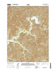
2017 Map of Starvout Creek
USGS Topo · Published 2017About this map
Galesville Reservoir dominates the upper elevations of this Southern Oregon landscape, where the waters of Cow Creek and its many tributaries are managed for the region. The map reveals an intricate network of Bureau of Land Management routes, such as Hoopy Ridge Rd and the Ump-Cow Divide E, which navigate the steep terrain between Patrick Mtn and Green Mtn. This late-stage topographic study details the drainage systems of Starvout Cr and Whitehorse Cr, highlighting the importance of timber and water management in the Douglas and Jackson county borderlands. The presence of features like Old Timber and numerous spur roads suggests a landscape heavily shaped by forestry practices and the logistical requirements of maintaining access through the Skyline Ridge area.
Find a feature on this map
94 named features on this map. Tap any name to fly to it.
Don’t see what you’re looking for? This feature index may not catch every label — zoom into the map to look around manually.
Map Details
Editions of this 2017 Starvout Creek Map
This is the sole edition of this map. No revisions or reprints were ever made.
Other maps of this area

1904 · Riddle
USGS Topo · 1:125,000

1954 · Days Creek
USGS Topo · 1:62,500

1954 · Glendale
USGS Topo · 1:62,500

1954 · Wimer
USGS Topo · 1:62,500

1954 · Canyonville
USGS Topo · 1:62,500

1955 · Medford
USGS Topo · 1:250,000

1957 · Medford
USGS Topo · 1:250,000

1958 · Medford
USGS Topo · 1:250,000
1983 · Skeleton Mtn
USGS Topo · 1:24,000
1983 · King Mountain
USGS Topo · 1:24,000