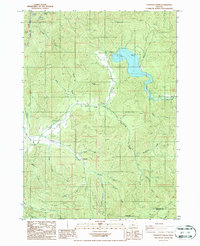
1986 Map of Starvout Creek
USGS Topo · Published 1987About this map
Galesville Dam and its reservoir dominate the northern landscape of this mid-1980s survey, marking a significant hydrological intervention in the drainage basin of the West Fork Cow Creek. The map documents a rugged timber and watershed area where the reservoir's Spillway and nearby Boat Ramp indicate the shift toward managed recreation and water storage.
Find a feature on this map
34 named features on this map. Tap any name to fly to it.
Don’t see what you’re looking for? This feature index may not catch every label — zoom into the map to look around manually.
Map Details
Editions of this 1986 Starvout Creek Map
This is the sole edition of this map. No revisions or reprints were ever made.
Other maps of this area

1904 · Riddle
USGS Topo · 1:125,000

1954 · Days Creek
USGS Topo · 1:62,500

1954 · Glendale
USGS Topo · 1:62,500

1954 · Wimer
USGS Topo · 1:62,500

1954 · Canyonville
USGS Topo · 1:62,500

1955 · Medford
USGS Topo · 1:250,000

1957 · Medford
USGS Topo · 1:250,000

1958 · Medford
USGS Topo · 1:250,000
1983 · Skeleton Mtn
USGS Topo · 1:24,000
1983 · King Mountain
USGS Topo · 1:24,000