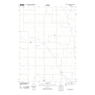
2010 Map of State Center NW
USGS Topo · Published 2010About this map
Saint Anthony anchors the southern boundary of this central Iowa landscape, where the headwaters of the Minerva and Mud Creek systems carve through a grid of rural section roads. The area is characterized by small, established clusters like Illinois Grove and Bivens Grove, reflecting a settlement pattern tied to the local timber and water resources of the nineteenth century. Genealogists can find significant local history preserved at Illinois Grove Cemetery, Chester Cemetery, and Saint Johns Cemetery, which serve as quiet markers of the families who farmed these fields. A notable crossing, the Minerva Creek Bridge, spans the winding Minerva Creek as it flows southeast, while the branching paths of Middle Minerva Creek and Mud Creek define the natural drainage of the territory.
Find a feature on this map
43 named features on this map. Tap any name to fly to it.
Don’t see what you’re looking for? This feature index may not catch every label — zoom into the map to look around manually.
Map Details
Editions of this 2010 State Center NW Map
This is the sole edition of this map. No revisions or reprints were ever made.
Other maps of this area

1954 · Waterloo
USGS Topo · 1:250,000

1955 · Waterloo
USGS Topo · 1:250,000

1975 · State Center NW
USGS Topo · 1:24,000

1975 · State Center
USGS Topo · 1:24,000

1975 · Union
USGS Topo · 1:24,000

1975 · Zearing
USGS Topo · 1:24,000
1975 · La Moille
USGS Topo · 1:24,000
1975 · Colo
USGS Topo · 1:24,000

1979 · New Providence
USGS Topo · 1:24,000

1979 · Hubbard
USGS Topo · 1:24,000