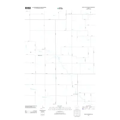
2013 Map of State Center NW
USGS Topo · Published 2013About this map
Illinois Grove and Bivens Grove anchor this Marshall County landscape, where the agricultural grid of Central Iowa is defined by a dense network of numbered streets and avenues. The terrain is structured around the winding paths of Minerva Cr and its tributary, Middle Minerva Cr, which cut through the township's rectangular plots. Evidence of local infrastructure is prominent, notably the Minerva Creek Bridge and the intersection of major thoroughfares like Co Hwy-D65 and Co Hwy-S57. The map illustrates a rural economy organized around these waterways and the sophisticated road system that connects isolated farmsteads. Stream branches like Mud Cr and Honey Cr further segment the northern reaches of the quadrangle, reflecting the natural drainage patterns that have influenced land use and settlement since the earliest pioneers arrived in the region.
Find a feature on this map
46 named features on this map. Tap any name to fly to it.
Don’t see what you’re looking for? This feature index may not catch every label — zoom into the map to look around manually.
Map Details
Editions of this 2013 State Center NW Map
This is the sole edition of this map. No revisions or reprints were ever made.
Other maps of this area

1954 · Waterloo
USGS Topo · 1:250,000

1955 · Waterloo
USGS Topo · 1:250,000

1975 · State Center NW
USGS Topo · 1:24,000

1975 · State Center
USGS Topo · 1:24,000

1975 · Union
USGS Topo · 1:24,000

1975 · Zearing
USGS Topo · 1:24,000
1975 · La Moille
USGS Topo · 1:24,000
1975 · Colo
USGS Topo · 1:24,000

1979 · New Providence
USGS Topo · 1:24,000

1979 · Hubbard
USGS Topo · 1:24,000