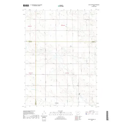
2018 Map of State Center NW
USGS Topo · Published 2018About this map
St. Anthony serves as the primary community in this rural section of Central Iowa, where the borders of Hardin, Story, and Marshall counties converge. The landscape is defined by the winding paths of Minerva Creek and its tributary, Middle Minerva Cr, which flow through a grid of agricultural section lines. This 2018 survey reveals a territory deeply rooted in its pioneer-era foundations, as evidenced by several localized burial grounds such as Illinois Grove Cem and Bevins Grove Cem. The presence of the Minerva Creek Bridge and numerous country roads, including Co Hwy E18, illustrates the enduring infrastructure that connects these small settlements and outlying farmsteads. Researchers can observe how the drainage patterns of Mud Cr and Honey Cr influenced the placement of original land claims and cemeteries like Saint Johns Cem and Chester Cem.
Find a feature on this map
35 named features on this map. Tap any name to fly to it.
Don’t see what you’re looking for? This feature index may not catch every label — zoom into the map to look around manually.
Map Details
Editions of this 2018 State Center NW Map
This is the sole edition of this map. No revisions or reprints were ever made.
Other maps of this area

1954 · Waterloo
USGS Topo · 1:250,000

1955 · Waterloo
USGS Topo · 1:250,000

1975 · State Center NW
USGS Topo · 1:24,000

1975 · State Center
USGS Topo · 1:24,000

1975 · Union
USGS Topo · 1:24,000

1975 · Zearing
USGS Topo · 1:24,000
1975 · La Moille
USGS Topo · 1:24,000
1975 · Colo
USGS Topo · 1:24,000

1979 · New Providence
USGS Topo · 1:24,000

1979 · Hubbard
USGS Topo · 1:24,000