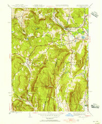
1944 Map of State Line
USGS Topo · Published 1956About this map
Richmond Furnace stands as a testament to the industrial history along the border of New York and Massachusetts during the mid-1940s. The landscape is defined by the sharp divide of the New York Massachusetts state line, where the infrastructure of the New York Massachusetts and Albany RR and the New York New Haven and Hartford RR supported a region defined by both industry and rural education. Local life centered around small hubs like Austerlitz and Williamsville, with rural schools such as Red Rock Sch and Fog Hill Sch serving the scattered hill farm populations.
Find a feature on this map
71 named features on this map. Tap any name to fly to it.
Don’t see what you’re looking for? This feature index may not catch every label — zoom into the map to look around manually.
Map Details
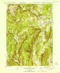
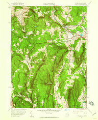
Editions of this 1944 State Line Map
3 editions found
Other maps of this area

1885 · Sheffield
USGS Topo · 1:62,500

1888 · Sheffield
USGS Topo · 1:62,500

1888 · Pittsfield
USGS Topo · 1:62,500

1890 · Pittsfield
USGS Topo · 1:62,500

1891 · Sheffield
USGS Topo · 1:62,500

1893 · Sheffield
USGS Topo · 1:62,500

1893 · Pittsfield
USGS Topo · 1:62,500

1894 · Pittsfield
USGS Topo · 1:62,500

1897 · Pittsfield
USGS Topo · 1:62,500

1897 · Sheffield
USGS Topo · 1:62,500