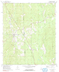
1974 Map of State Line
USGS Topo · Published 1991About this map
The Illinois Central Gulf railroad defines the transportation corridor of this borderland in the mid-1970s, running southeast through the town of State Line. This settlement, straddling the boundaries of Wayne and Greene counties in Mississippi and neighboring Alabama, serves as a hub for a landscape dotted with numerous country churches and cemeteries. Settlements such as Eret and Yellow Pine anchor the rural community, while the Escatawpa River and its tributaries like Red Bank Creek and Brushy Creek drain the surrounding timberlands and gas fields. The presence of multiple gas wells and sandpits suggests a diversified local economy beyond agriculture. Genealogists will find significant value in the mapped locations of family and community landmarks, including Seven Oak Cem Ch, Mt Moriah Ch, and the Milstead Lookout Tower, which provide specific points of reference for twentieth-century Mississippi and Alabama history.
Find a feature on this map
36 named features on this map. Tap any name to fly to it.
Don’t see what you’re looking for? This feature index may not catch every label — zoom into the map to look around manually.
Map Details
Editions of this 1974 State Line Map
2 editions found
Other maps of this area

1953 · Hattiesburg
USGS Topo · 1:250,000

1958 · Hattiesburg
USGS Topo · 1:250,000

1964 · Knobtown
USGS Topo · 1:24,000

1964 · Clark
USGS Topo · 1:24,000

1964 · Buckatunna
USGS Topo · 1:24,000

1974 · Fruitdale
USGS Topo · 1:24,000

1974 · Millry South
USGS Topo · 1:24,000

1974 · Chatom
USGS Topo · 1:24,000

1974 · State Line
USGS Topo · 1:24,000

1974 · Copeland
USGS Topo · 1:24,000