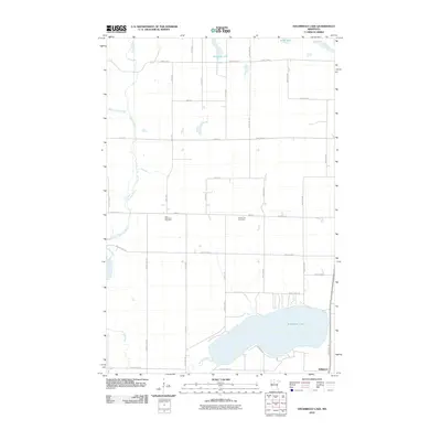
2010 Map of Steamboat Lake
USGS Topo · Published 2010About this map
Steamboat Lake and the meandering path of the Necktie River define this rural northern Minnesota landscape during the first decade of the 2000s. The settlement of Wilkinson sits at the southeastern corner of the quadrangle, serving as a focal point near the lake's shores where the Heartland Trl follows an established transit corridor. The map reveals a highly structured grid of section lines and gravel roads, including County Hwy-5 and Cass Line Rd, which bisect the timbered and wetland-rich terrain of Cass County.
Find a feature on this map
37 named features on this map. Tap any name to fly to it.
Don’t see what you’re looking for? This feature index may not catch every label — zoom into the map to look around manually.
Map Details
Editions of this 2010 Steamboat Lake Map
This is the sole edition of this map. No revisions or reprints were ever made.
Other maps of this area

1954 · Bemidji
USGS Topo · 1:250,000

1957 · Bemidji
USGS Topo · 1:250,000

1958 · Bemidji
USGS Topo · 1:250,000

1968 · Guthrie
USGS Topo · 1:24,000

1968 · Bemidji East
USGS Topo · 1:24,000

1972 · Steamboat Bay
USGS Topo · 1:24,000

1972 · Benedict
USGS Topo · 1:24,000

1972 · Laporte
USGS Topo · 1:24,000

1972 · Pike Bay
USGS Topo · 1:24,000
1972 · Cass Lake
USGS Topo · 1:24,000