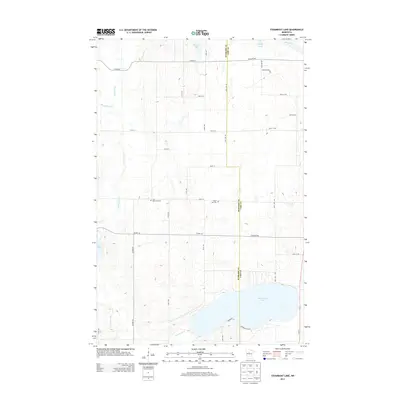
2013 Map of Steamboat Lake
USGS Topo · Published 2013About this map
The Necktie River meanders through this portion of the northern Minnesota lake country, defining a landscape shaped by glacial depressions and water systems. Along the border between Hubbard Co and Cass Co, a network of county roads like Co HWY-16 and Co HWY-45 connects the rural landscape. This area is characterized by numerous small basins and larger bodies of water, most notably Steamboat Lake in the southeast and Hart Lake to the west. Evidence of local heritage is preserved at sites like Zion Memorial Cem and Green Lea Cem, which sit among the low ridges and wetland fringes. The drainage patterns of Bungashing Cr and Fox Creek further illustrate the intricate hydrology of this region, providing a detailed look at the terrain before modern development intensified in the surrounding counties.
Find a feature on this map
38 named features on this map. Tap any name to fly to it.
Don’t see what you’re looking for? This feature index may not catch every label — zoom into the map to look around manually.
Map Details
Editions of this 2013 Steamboat Lake Map
This is the sole edition of this map. No revisions or reprints were ever made.
Other maps of this area

1954 · Bemidji
USGS Topo · 1:250,000

1957 · Bemidji
USGS Topo · 1:250,000

1958 · Bemidji
USGS Topo · 1:250,000

1968 · Guthrie
USGS Topo · 1:24,000

1968 · Bemidji East
USGS Topo · 1:24,000

1972 · Steamboat Bay
USGS Topo · 1:24,000

1972 · Benedict
USGS Topo · 1:24,000

1972 · Laporte
USGS Topo · 1:24,000

1972 · Pike Bay
USGS Topo · 1:24,000
1972 · Cass Lake
USGS Topo · 1:24,000