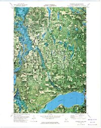
1972 Map of Steamboat Lake
USGS Topo · Published 1974About this map
Steamboat Lake and the winding Necktie River dominate this 1970s orthophotomap, which captures the dense woodland and wetland interface within the Chippewa National Forest. The landscape is defined by its complex hydrography, featuring numerous smaller bodies of water like Bowman Lake, Spike Lake, and Richard Lake. The map highlights the boundary between Hubbard and Cass Counties, much of which lies within the Leech Lake Indian Reservation.
Find a feature on this map
18 named features on this map. Tap any name to fly to it.
Don’t see what you’re looking for? This feature index may not catch every label — zoom into the map to look around manually.
Map Details
Editions of this 1972 Steamboat Lake Map
This is the sole edition of this map. No revisions or reprints were ever made.
Other maps of this area

1954 · Bemidji
USGS Topo · 1:250,000

1957 · Bemidji
USGS Topo · 1:250,000

1958 · Bemidji
USGS Topo · 1:250,000

1968 · Guthrie
USGS Topo · 1:24,000

1968 · Bemidji East
USGS Topo · 1:24,000

1972 · Steamboat Bay
USGS Topo · 1:24,000

1972 · Benedict
USGS Topo · 1:24,000

1972 · Laporte
USGS Topo · 1:24,000

1972 · Pike Bay
USGS Topo · 1:24,000
1972 · Cass Lake
USGS Topo · 1:24,000