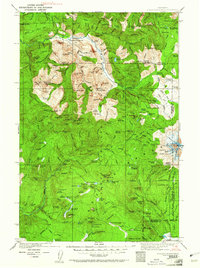
1926 Map of Steamboat Mtn
USGS Topo · Published 1961About this map
The Gifford Pinchot National Forest dominates this mid-1920s survey, documenting a landscape of high alpine glaciers and early forest management. Mount Adams anchors the eastern edge, with the Adams Glacier, White Salmon Glacier, and Pinnacle Glacier flowing from its slopes into the headwaters of the Lewis River and White Salmon River. Settlement is limited to isolated outposts like Guler in the south and the Tower Rock Ranger Sta near the Cispus River, reflecting the region's focus on timber and mining during this era. Trace the path of the Cascade Crest Trail as it winds past the Williams Mine and various mountain camps like Midway Camp and Squaw Camp. The map's detailed recording of numerous small lakes, such as Steamboat Lake and Placid Lake, provides a clear view of the wilderness before later recreational development.
Find a feature on this map
211 named features on this map. Tap any name to fly to it.
Don’t see what you’re looking for? This feature index may not catch every label — zoom into the map to look around manually.
Map Details
Editions of this 1926 Steamboat Mtn Map
3 editions found
Other maps of this area

1902 · Mount Aix
USGS Topo · 1:125,000

1904 · Mt Aix
USGS Topo · 1:125,000

1904 · Mount Adams
USGS Topo · 1:125,000

1907 · Mount Adams
USGS Topo · 1:125,000

1919 · Mount St Helens
USGS Topo · 1:125,000

1924 · Mt Rainier
USGS Topo · 1:96,000

1926 · Steamboat Mtn
USGS Topo · 1:125,000

1926 · Hood River
USGS Topo · 1:125,000

1928 · Mt Rainier
USGS Topo · 1:125,000

1929 · Hood River
USGS Topo · 1:125,000