
1931 Map of Steamboat Mtn
USGS Topo · Published 1943About this map
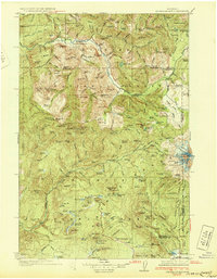
Columbia National Forest dominates this topographic record of the Cascade Range, surveyed in the mid-1920s. The landscape is defined by the drainage systems of the Cispus River and Lewis River, where human presence is primarily marked by forest management and resource extraction. Ranger stations such as Berry Patch Ranger Sta and Tower Rock Ranger Sta provided administrative hubs in this high-elevation terrain. The presence of the Williams Mine near Grand Meadow suggests the localized mineral prospecting common to the era.
Find a feature on this map
172 named features on this map. Tap any name to fly to it.
Don’t see what you’re looking for? This feature index may not catch every label — zoom into the map to look around manually.
Map Details
Editions of this 1931 Steamboat Mtn Map
2 editions found
Other maps of this area

1902 · Mount Aix
USGS Topo · 1:125,000

1904 · Mt Aix
USGS Topo · 1:125,000

1904 · Mount Adams
USGS Topo · 1:125,000

1907 · Mount Adams
USGS Topo · 1:125,000

1919 · Mount St Helens
USGS Topo · 1:125,000

1924 · Mt Rainier
USGS Topo · 1:96,000

1926 · Steamboat Mtn
USGS Topo · 1:125,000

1926 · Hood River
USGS Topo · 1:125,000

1928 · Mt Rainier
USGS Topo · 1:125,000

1929 · Hood River
USGS Topo · 1:125,000