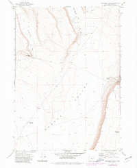
1971 Map of Steamboat Point
USGS Topo · Published 1980About this map
Warner Valley dominates this 1971 landscape, a high-desert basin in Harney County where the terrain shifts from flat valley floor to the dramatic escarpments of Steamboat Point and Orijana. The map reveals a remote environment shaped by the necessities of livestock management and wildlife protection, evidenced by the Antelope Refuge Bddry stretching along its eastern edge. Water management in this arid corridor is central to the land's utility, marked by isolated sites like Drift Fence Waterhole, Middle Lake Waterhole, and Chrome Reservoir.
Find a feature on this map
11 named features on this map. Tap any name to fly to it.
Don’t see what you’re looking for? This feature index may not catch every label — zoom into the map to look around manually.
Map Details
Editions of this 1971 Steamboat Point Map
2 editions found
Other maps of this area

1955 · Adel
USGS Topo · 1:250,000

1957 · Adel
USGS Topo · 1:250,000

1958 · Adel
USGS Topo · 1:250,000

1962 · Adel
USGS Topo · 1:250,000

1966 · Bluejoint Lake East
USGS Topo · 1:24,000

1967 · Bluejoint Lake West
USGS Topo · 1:24,000

1971 · Steamboat Point
USGS Topo · 1:24,000

1971 · Orejana Canyon
USGS Topo · 1:24,000

1971 · Rock Camp Draw
USGS Topo · 1:24,000
1971 · Sixmile Draw
USGS Topo · 1:24,000