
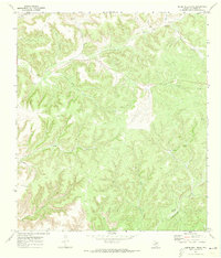
1970 Map of Steel Star Draw
USGS Topo · Published 1973About this map
The Oppenheimer ranchlands and surrounding draws of Val Verde County define this West Texas landscape as it appeared in the late 1960s. The topography is dominated by an intricate network of seasonal drainage channels, most notably Steel Star Draw, Samson Draw, and Duncan Draw, which carve through the high plateau towards the Devils River. This map provides a detailed view of the remote ranching infrastructure of the era, marking the locations of the Oberkampf Ranch, Nettleford Ranch, and Carson Ranch. These working landscapes were supported by several private landing strips and a Radio Tower, reflecting the logistical realities of managing large-scale livestock operations in such isolated territory. Small-scale industrial activity is also present, indicated by a Gravel Pit, a Gas Well, and scattered drill holes, suggesting mineral exploration alongside traditional grazing.
Find a feature on this map
20 named features on this map. Tap any name to fly to it.
Don’t see what you’re looking for? This feature index may not catch every label — zoom into the map to look around manually.
Map Details
Editions of this 1970 Steel Star Draw Map
This is the sole edition of this map. No revisions or reprints were ever made.
Other maps of this area

1954 · Sonora
USGS Topo · 1:250,000

1958 · Sonora
USGS Topo · 1:250,000

1970 · Everett Canyon
USGS Topo · 1:24,000

1970 · Aermotor Draw
USGS Topo · 1:24,000

1970 · Indian Draw
USGS Topo · 1:24,000

1970 · Sycamore Canyon
USGS Topo · 1:24,000

1970 · Blue Hills
USGS Topo · 1:24,000

1970 · Bee Canyon
USGS Topo · 1:24,000

1970 · Howards Well SW
USGS Topo · 1:24,000
1970 · Divide Well Draw
USGS Topo · 1:24,000