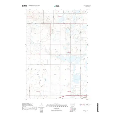
2018 Map of Steele NE
USGS Topo · Published 2018About this map
Dawson sits at the southern edge of this landscape, positioned along a primary east-west transport corridor. The surrounding terrain is defined by a dense network of prairie potholes and larger water bodies, most notably Buffalo Lake and the nearby Dead Buffalo Lake. To the east, Big Muddy Lake spans the border of this quadrangle, illustrating the complex hydrography characteristic of this part of Kidder County. For those tracing family history in the area, the Allen Cem is located in the western portion of the map, situated north of 34th St SE. The landscape is organized by a strict grid of section lines and gravel roads, including 29th St SE through 37th St SE, which provide access to the various townships such as t140n r72w.
Find a feature on this map
20 named features on this map. Tap any name to fly to it.
Don’t see what you’re looking for? This feature index may not catch every label — zoom into the map to look around manually.
Map Details
Editions of this 2018 Steele NE Map
This is the sole edition of this map. No revisions or reprints were ever made.
Other maps of this area

1952 · Tappen South
USGS Topo · 1:24,000

1952 · Dawson
USGS Topo · 1:24,000

1952 · Tappen North
USGS Topo · 1:24,000

1952 · Steele NE
USGS Topo · 1:24,000

1952 · Steele
USGS Topo · 1:24,000

1952 · Steele NW
USGS Topo · 1:24,000

1952 · New Rockford
USGS Topo · 1:250,000

1953 · Jamestown
USGS Topo · 1:250,000

1956 · New Rockford
USGS Topo · 1:250,000

1956 · Jamestown
USGS Topo · 1:250,000