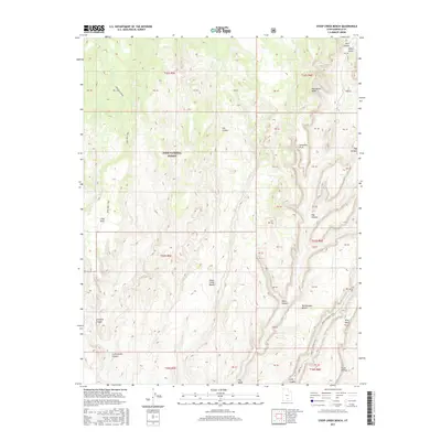
2017 Map of Steep Creek Bench
USGS Topo · Published 2017About this map
The Dixie National Forest covers much of this landscape, dominated by high desert plateaus and deeply carved canyons. The terrain is defined by dramatic geological formations, including the prominent Impossible Peak and the hidden Lamanite Arch. Travel through this region relies on historic routes such as the Burr Trl and the Long Neck Trail, which navigate the complex elevations between Steep Creek Bench and Rattlesnake Bench. The drainage system is equally intricate, with Steep Cr and Frisky Cr cutting through the colorful strata. From the northern reaches of Stair Canyon to the southern expanse of the Circle Cliffs, the map reveals a wilderness area shaped by erosion, where named features like Egg Canyon and Slickrock Canyon provide vital navigation points in an otherwise daunting vertical environment.
Find a feature on this map
47 named features on this map. Tap any name to fly to it.
Don’t see what you’re looking for? This feature index may not catch every label — zoom into the map to look around manually.
Map Details
Editions of this 2017 Steep Creek Bench Map
This is the sole edition of this map. No revisions or reprints were ever made.
Other maps of this area

1885 · Fish Lake
USGS Topo · 1:250,000

1886 · Escalante
USGS Topo · 1:250,000

1896 · Fish Lake
USGS Topo · 1:250,000

1952 · Notom 3 SW
USGS Topo · 1:24,000

1952 · Notom 4 SW
USGS Topo · 1:24,000

1952 · Notom 3 SE
USGS Topo · 1:24,000

1952 · Grover
USGS Topo · 1:62,500

1952 · Notom
USGS Topo · 1:62,500

1953 · Circle Cliffs 2 NE
USGS Topo · 1:24,000

1953 · Circle Cliffs 1 SW
USGS Topo · 1:24,000