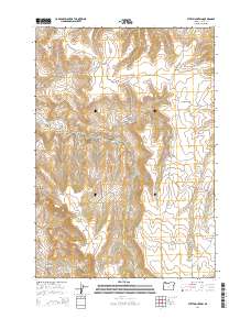
2014 Map of Steet Mountain
USGS Topo · Published 2014About this map
Steet Mountain anchors this high-elevation landscape in Grant County, where the terrain is deeply incised by a dense network of canyons and gulches. The drainage pattern is particularly intricate, with Jinks Cr and Deer Cr carving through the western and central portions of the quadrangle. In the southwest corner, Schoolhouse Hill and its associated Schoolhouse Hill Spring provide evidence of former local land use and landmarking in an otherwise sparse wilderness. The only major infrastructure is the Kimberly-Long Creek Hwy, which skirts the southwestern boundary alongside the E Fork Cottonwood Cr. This topographic study reveals a landscape defined by names like Sheepshed Canyon and Perry Wilson Canyon, suggesting a history tied to seasonal grazing and individual land claims common in eastern Oregon's high desert fringe.
Find a feature on this map
27 named features on this map. Tap any name to fly to it.
Don’t see what you’re looking for? This feature index may not catch every label — zoom into the map to look around manually.
Map Details
Editions of this 2014 Steet Mountain Map
This is the sole edition of this map. No revisions or reprints were ever made.
Other maps of this area

1949 · Long Creek
USGS Topo · 1:62,500

1950 · Ritter
USGS Topo · 1:62,500

1951 · Long Creek
USGS Topo · 1:62,500

1951 · Courtrock
USGS Topo · 1:62,500

1951 · Monument
USGS Topo · 1:62,500

1952 · Ritter
USGS Topo · 1:62,500

1955 · Canyon City
USGS Topo · 1:250,000

1959 · Canyon City
USGS Topo · 1:250,000

1980 · Monument
USGS Topo · 1:100,000
1990 · Monument
USGS Topo · 1:24,000