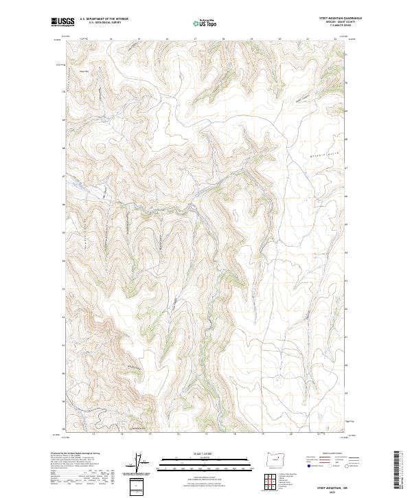
2023 Map of Steet Mountain
USGS Topo · Published 2023About this map
Steet Mtn rises as the central landmark in this 2023 survey of Grant County, Oregon, defining a landscape carved by a complex network of canyons and gulches. The terrain is notably dissected by drainages named for early settlers and local geography, such as Perry Wilson Canyon, Howard Canyon, and Mail Canyon. The map reveals a history of rural infrastructure in the southwest corner, where Schoolhouse Hill and the nearby Schoolhouse Spring suggest the location of an earlier community gathering point near East Fork Cottonwood Creek.
Find a feature on this map
26 named features on this map. Tap any name to fly to it.
Don’t see what you’re looking for? This feature index may not catch every label — zoom into the map to look around manually.
Map Details
Editions of this 2023 Steet Mountain Map
This is the sole edition of this map. No revisions or reprints were ever made.
Other maps of this area

1949 · Long Creek
USGS Topo · 1:62,500

1950 · Ritter
USGS Topo · 1:62,500

1951 · Long Creek
USGS Topo · 1:62,500

1951 · Courtrock
USGS Topo · 1:62,500

1951 · Monument
USGS Topo · 1:62,500

1952 · Ritter
USGS Topo · 1:62,500

1955 · Canyon City
USGS Topo · 1:250,000

1959 · Canyon City
USGS Topo · 1:250,000

1980 · Monument
USGS Topo · 1:100,000
1990 · Monument
USGS Topo · 1:24,000