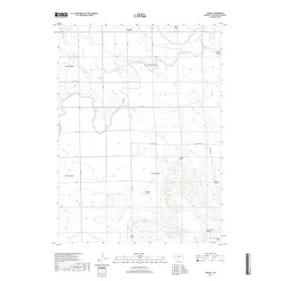
2017 Map of Stegall
USGS Topo · Published 2017About this map
Signal Butte stands as a prominent landmark in this corner of Scotts Bluff County, Nebraska, where the high plains meet the intricate breaks of the Wildcat Hills. This landscape is defined by the sophisticated irrigation infrastructure necessary for agriculture in the region, centered on the winding path of the Fort Laramie Canal. A network of specialized waterways, including Butcher Drain, McCreary Drain, and the Kiowa Diversion Lateral Number 1, supports the fields surrounding the small settlement of Stegall. To the south, the terrain becomes increasingly complex as it rises into the hills, cut by numerous named drainages such as Bobcat Canyon and Andys Canyon. The local road system, including Kiowa Church Rd and Roubadeau Pass Rd, provides a trace of the rural community's layout and its connection to the surrounding ranching and farming operations during the early 21st century.
Find a feature on this map
40 named features on this map. Tap any name to fly to it.
Don’t see what you’re looking for? This feature index may not catch every label — zoom into the map to look around manually.
Map Details
Editions of this 2017 Stegall Map
This is the sole edition of this map. No revisions or reprints were ever made.
Other maps of this area

1898 · Scotts Bluff
USGS Topo · 1:125,000

1899 · Goshen Hole
USGS Topo · 1:125,000

1954 · Scottsbluff
USGS Topo · 1:250,000

1954 · Cheyenne
USGS Topo · 1:250,000

1958 · Cheyenne
USGS Topo · 1:250,000

1958 · Scottsbluff
USGS Topo · 1:250,000

1960 · Mc Compsey Pass
USGS Topo · 1:24,000

1960 · Lyman
USGS Topo · 1:24,000

1960 · Stegall
USGS Topo · 1:24,000

1960 · Murray Lake
USGS Topo · 1:24,000