
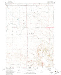
1960 Map of Stegall
USGS Topo · Published 1962About this map
The Union Pacific railroad cuts through the northern edge of this Nebraska panhandle landscape, anchoring the small settlement of Stegall. This area of Scotts Bluff County is defined by a sophisticated network of irrigation and water management, including the Fort Laramie Canal, Lowery Reservoir, and numerous specialized channels like the Kiowa Diversion Canal and McCreary Drain. This infrastructure reflects the region's agricultural transition, where diverted water from the North Platte River transformed the arid plains. Notable community landmarks such as the Kiowa Community Ch and Wheatland Sch are found among the section lines. To the southeast, the terrain shifts abruptly from flat farmland into the broken ridges of the Wildcat Hills, highlighted by the prominent Signal Butte and the deep cuts of Bobcat Canyon and Spring Canyon.
Find a feature on this map
29 named features on this map. Tap any name to fly to it.
Don’t see what you’re looking for? This feature index may not catch every label — zoom into the map to look around manually.
Map Details
Editions of this 1960 Stegall Map
2 editions found
Other maps of this area

1898 · Scotts Bluff
USGS Topo · 1:125,000

1899 · Goshen Hole
USGS Topo · 1:125,000

1954 · Scottsbluff
USGS Topo · 1:250,000

1954 · Cheyenne
USGS Topo · 1:250,000

1958 · Cheyenne
USGS Topo · 1:250,000

1958 · Scottsbluff
USGS Topo · 1:250,000

1960 · Mc Compsey Pass
USGS Topo · 1:24,000

1960 · Lyman
USGS Topo · 1:24,000

1960 · Murray Lake
USGS Topo · 1:24,000
1960 · Robb Draw
USGS Topo · 1:24,000