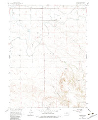
1960 Map of Stegall
USGS Topo · Published 1983About this map
The rugged topography of the Wildcat Hills dominates the southern portion of this landscape, rising sharply above the agricultural plains below. This 1960 field-checked survey reveals an intricate irrigation network essential to the high plains economy, featuring the Fort Laramie Canal and several specialized water systems like the West Bald Peak Lateral and Kiowa Drain. These engineering works, alongside the Union Pacific railroad corridor at the northern edge, supported the small community hubs of the era.
Find a feature on this map
31 named features on this map. Tap any name to fly to it.
Don’t see what you’re looking for? This feature index may not catch every label — zoom into the map to look around manually.
Map Details
Editions of this 1960 Stegall Map
2 editions found
Other maps of this area

1898 · Scotts Bluff
USGS Topo · 1:125,000

1899 · Goshen Hole
USGS Topo · 1:125,000

1954 · Scottsbluff
USGS Topo · 1:250,000

1954 · Cheyenne
USGS Topo · 1:250,000

1958 · Cheyenne
USGS Topo · 1:250,000

1958 · Scottsbluff
USGS Topo · 1:250,000

1960 · Mc Compsey Pass
USGS Topo · 1:24,000

1960 · Lyman
USGS Topo · 1:24,000

1960 · Stegall
USGS Topo · 1:24,000

1960 · Murray Lake
USGS Topo · 1:24,000