
1902 Map of Stehekin
USGS Topo · Published 1955About this map
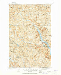
Lake Chelan serves as the focal point for this wilderness landscape, where early twentieth-century surveying documented the remote outposts of the North Cascades. The settlement of Stehekin sits at the head of the lake, acting as the primary gateway for the Stehekin River valley. To the south, the village of Lucerne provides access to the interior, where the Holden Railroad and the mining camp at Holden are nestled along the drainage of Railroad Creek. This era of development is defined by a reliance on water-borne transport and rugged mountain trails, including the Purple Creek Trail and the passage over Twisp Pass.
Find a feature on this map
114 named features on this map. Tap any name to fly to it.
Don’t see what you’re looking for? This feature index may not catch every label — zoom into the map to look around manually.
Map Details
Editions of this 1902 Stehekin Map
2 editions found
Other maps of this area

1899 · Glacier Peak
USGS Topo · 1:125,000

1899 · Methow
USGS Topo · 1:125,000

1901 · Glacier Peak
USGS Topo · 1:125,000

1901 · Chelan
USGS Topo · 1:125,000

1901 · Methow
USGS Topo · 1:125,000

1901 · Chiwaukum
USGS Topo · 1:125,000

1902 · Skykomish
USGS Topo · 1:125,000

1904 · Stehekin
USGS Topo · 1:125,000

1904 · Chiwaukum
USGS Topo · 1:125,000

1905 · Skykomish
USGS Topo · 1:125,000