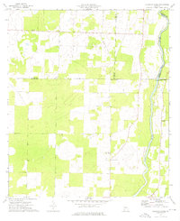
1974 Map of Steinham Store
USGS Topo · Published 1976About this map
Steinham Store serves as a central landmark in this Southwest Georgia landscape, where the agricultural plains meet the winding course of the Flint River. The 1974 survey documents a rural community defined by its spiritual centers, including First Macedonia Ch, Pilgrims Rest Ch, and Mt Tabor Ch. These small church congregations are scattered across a terrain where land-use patterns are shaped by complex county boundaries, as the borders of Miller, Baker, Decatur, and Mitchell counties all converge in this vicinity. Economic activity is represented by localized industry like the Sandpit found in the northern reaches. The map provides a detailed view of the rural road network and drainage patterns typical of the coastal plain before significant late-twentieth-century development altered the local character.
Find a feature on this map
11 named features on this map. Tap any name to fly to it.
Don’t see what you’re looking for? This feature index may not catch every label — zoom into the map to look around manually.
Map Details
Editions of this 1974 Steinham Store Map
This is the sole edition of this map. No revisions or reprints were ever made.
Other maps of this area

1953 · Dothan
USGS Topo · 1:250,000

1954 · Dothan
USGS Topo · 1:250,000

1954 · Tallahassee
USGS Topo · 1:250,000

1955 · Dothan
USGS Topo · 1:250,000

1955 · Bainbridge
USGS Topo · 1:62,500

1955 · Whigham
USGS Topo · 1:62,500

1959 · Tallahassee
USGS Topo · 1:250,000

1960 · Tallahassee
USGS Topo · 1:250,000

1971 · Vada
USGS Topo · 1:24,000

1971 · Hopeful
USGS Topo · 1:24,000