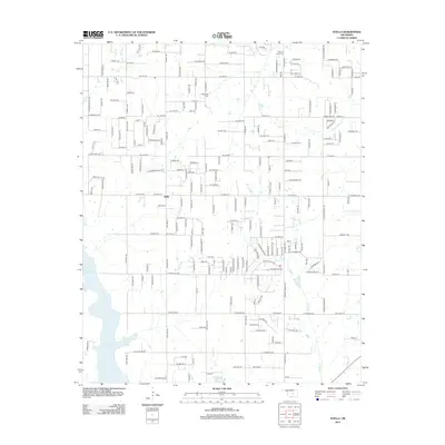
2012 Map of Stella
USGS Topo · Published 2012About this map
Stella serves as the central community in this rural expanse of Oklahoma, where the landscape is defined by the headwaters and tributaries of several local waterways. The eastern shoreline of Lake Thunderbird enters the frame from the west, while smaller water bodies like Reynolds Lake and the winding course of Pecan Cr drain the surrounding countryside. This 2012 survey illustrates a transition from larger agricultural plots to more structured residential divisions, evidenced by the dense grid of street names such as E Stella Rd and E Indian Hills Rd. For those researching local family history, several prominent burial grounds are documented, including Stella Cem, Friendship Cem, and Pilgrims Rest Cem near the northern boundary, alongside Knoles Cem further south, providing fixed points of reference in a developing suburban landscape.
Find a feature on this map
91 named features on this map. Tap any name to fly to it.
Don’t see what you’re looking for? This feature index may not catch every label — zoom into the map to look around manually.
Map Details
Editions of this 2012 Stella Map
This is the sole edition of this map. No revisions or reprints were ever made.
Other maps of this area

1892 · Moore
USGS Topo · 1:62,500

1893 · Norman
USGS Topo · 1:62,500

1898 · Purcell
USGS Topo · 1:125,000

1910 · McComb
USGS Topo · 1:62,500

1930 · McLoud
USGS Topo · 1:62,500

1934 · Moore
USGS Topo · 1:62,500

1936 · Norman
USGS Topo · 1:62,500

1938 · Moore
USGS Topo · 1:62,500

1954 · Oklahoma City
USGS Topo · 1:250,000
1956 · Choctaw
USGS Topo · 1:24,000