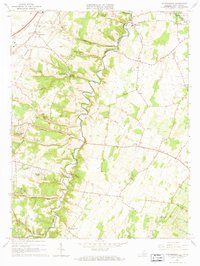
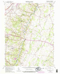
1966 Map of Stephenson
USGS Topo · Published 1967About this map
Opequon Creek meanders along the boundary of Frederick and Clarke counties, anchoring a rural landscape defined by historic crossings and institutional sites. Near Jordan Springs, the Holy Trinity Mission Seminary stands as a prominent landmark amidst the rolling terrain of the Backbone ridge. This mid-1960s survey records a network of established communities such as Stephenson and Wadesville, alongside several rural religious centers including Old Salem Ch Cem, Stones Chapel, and Crumps Ch. The presence of the Baltimore and Ohio railroad and proximity to the County Fairgrounds suggests an area transitioning from pure agriculture to more varied uses, while smaller settlements like Burnt Factory and Freyco preserve the names of earlier industrial and local hubs.
Find a feature on this map
49 named features on this map. Tap any name to fly to it.
Don’t see what you’re looking for? This feature index may not catch every label — zoom into the map to look around manually.
Map Details
Editions of this 1966 Stephenson Map
5 editions found
Other maps of this area

1884 · Harpers Ferry
USGS Topo · 1:125,000

1891 · Harpers Ferry
USGS Topo · 1:125,000

1893 · Harpers Ferry
USGS Topo · 1:125,000

1894 · Winchester
USGS Topo · 1:125,000

1914 · Martinsburg
USGS Topo · 1:48,000

1914 · Gerrardstown
USGS Topo · 1:48,000

1916 · Gerrardstown
USGS Topo · 1:62,500

1916 · Martinsburg
USGS Topo · 1:62,500

1916 · Berryville
USGS Topo · 1:62,500

1937 · Gerrardstown
USGS Topo · 1:48,000