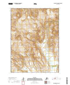
2020 Map of Stepovak Bay D-6 NW
USGS Topo · Published 2020About this map
The Aleutian Range dominates this portion of the Alaska Peninsula, where the high-altitude terrain creates a natural divide between the Aleutians East Borough and the Lake and Peninsula Borough. Surveyed in 2020 by the U.S. Geological Survey, this topographical study reveals a landscape defined by extreme elevation changes and glacial activity rather than human settlement. The map serves as a detailed record of the physical geography at the southwestern edge of the Alaskan mainland, capturing the complex drainage patterns and ridgelines of the range before they descend toward the surrounding maritime bays. It is a vital document for understanding the undeveloped wilderness and administrative boundaries of this remote subarctic region.
Find a feature on this map
10 named features on this map. Tap any name to fly to it.
Don’t see what you’re looking for? This feature index may not catch every label — zoom into the map to look around manually.
Map Details
Editions of this 2020 Stepovak Bay D-6 NW Map
This is the sole edition of this map. No revisions or reprints were ever made.
Other maps of this area

1951 · Stepovak Bay
USGS Topo · 1:250,000

1953 · Port Moller
USGS Topo · 1:250,000

1963 · Chignik A-6
USGS Topo · 1:63,360

1963 · Chignik A-7
USGS Topo · 1:63,360

1963 · Stepovak Bay D-6
USGS Topo · 1:63,360

1963 · Chignik
USGS Topo · 1:250,000

1963 · Stepovak Bay
USGS Topo · 1:250,000
1963 · Port Moller D-1
USGS Topo · 1:63,360

1969 · Stepovak Bay
USGS Topo · 1:250,000

1988 · Port Moller
USGS Topo · 1:250,000