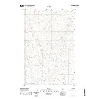
2020 Map of Stepstone Creek
USGS Topo · Published 2020About this map
Nespelem River winds through the southern portion of this Okanogan County landscape, providing the primary drainage for a network of mountain streams. The terrain is defined by a series of north-south running drainages including Stepstone Cr, N Star Cr, and Parmenter Cr. This modern survey illustrates a heavily managed forest environment, dominated by a dense grid of Bureau of Indian Affairs access routes such as Bia RD 62 and Bia RD 1130. Notable water bodies like Gold Lake in the north and Little Owhi Lake in the southeast serve as significant landmarks within the mountainous topography. The concentration of labeled streams and BIA roads suggests an area deeply integrated into regional land management and forestry practices, while features like Owhi Cr and Kinkaid Cr highlight the intricate local hydrology.
Find a feature on this map
25 named features on this map. Tap any name to fly to it.
Don’t see what you’re looking for? This feature index may not catch every label — zoom into the map to look around manually.
Map Details
Editions of this 2020 Stepstone Creek Map
This is the sole edition of this map. No revisions or reprints were ever made.
Other maps of this area

1950 · Nespelem
USGS Topo · 1:62,500

1950 · Alameda Flat
USGS Topo · 1:62,500

1952 · Alameda Flat
USGS Topo · 1:62,500

1952 · Disautel
USGS Topo · 1:62,500

1953 · Bald Knob
USGS Topo · 1:62,500

1954 · Okanogan
USGS Topo · 1:250,000

1958 · Okanogan
USGS Topo · 1:250,000
1983 · Omak
USGS Topo · 1:100,000

1984 · Nespelem
USGS Topo · 1:100,000

1986 · Central Peak
USGS Topo · 1:24,000