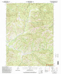
1996 Map of Sterling Creek
USGS Topo · Published 1998About this map
Buncom and the surrounding timberlands of the Rogue River National Forest define this 1996 survey of Jackson County. The landscape is characterized by a dense network of gulches and ridges, including Bear Cabin Ridge and Hopkins Ridge, feeding into the Little Applegate River and Sterling Creek. Evidence of historic resource extraction is visible through multiple Tailings deposits along the creek beds, particularly near a small Cem and Sailor Gulch. To the north, Nelson Mountain and its associated Nelson Meadow provide significant elevation markers, while the Barr Ranch indicates continuing land use in the valleys. The map illustrates the intersection of Forest Service management and private holdings, with the Little Applegate Recreation Site marking a transition toward modern recreational land use within the older mining and ranching geography.
Find a feature on this map
51 named features on this map. Tap any name to fly to it.
Don’t see what you’re looking for? This feature index may not catch every label — zoom into the map to look around manually.
Map Details
Editions of this 1996 Sterling Creek Map
This is the sole edition of this map. No revisions or reprints were ever made.
Other maps of this area

1891 · Ashland
USGS Topo · 1:250,000

1893 · Ashland
USGS Topo · 1:250,000

1897 · Ashland
USGS Topo · 1:250,000

1908 · Grants Pass
USGS Topo · 1:125,000

1938 · Medford
USGS Topo · 1:125,000

1954 · Medford
USGS Topo · 1:62,500

1954 · Gold Hill
USGS Topo · 1:62,500

1954 · Talent
USGS Topo · 1:62,500

1954 · Ruch
USGS Topo · 1:62,500

1955 · Medford
USGS Topo · 1:250,000