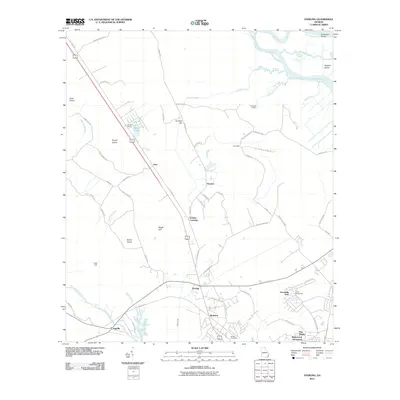
2011 Map of Sterling
USGS Topo · Published 2011About this map
Sterling and its surrounding communities in Glynn County emerge from a landscape defined by the lowlands and tidal waterways of coastal Georgia. The settlement pattern follows the corridor of Old Jesup Rd, where clusters of homes and transport points like Hunters Siding, Zuta, and Frazers Crossing mark the transition from inland pine forests to the sprawling river basins. To the south, the development of Ridgewood Plantation and Pine Haven indicates more modern residential growth near the historic hamlet of Brobston.
Find a feature on this map
67 named features on this map. Tap any name to fly to it.
Don’t see what you’re looking for? This feature index may not catch every label — zoom into the map to look around manually.
Map Details
Editions of this 2011 Sterling Map
This is the sole edition of this map. No revisions or reprints were ever made.
Other maps of this area

1918 · Everett City
USGS Topo · 1:62,500

1918 · Bladen
USGS Topo · 1:62,500

1920 · Everett City
USGS Topo · 1:62,500

1921 · Darien
USGS Topo · 1:62,500

1939 · Bladen
USGS Topo · 1:62,500

1944 · Everett City
USGS Topo · 1:62,500

1945 · Brunswick
USGS Topo · 1:62,500

1946 · Brunswick
USGS Topo · 1:250,000

1948 · Brunswick
USGS Topo · 1:250,000
1954 · Ridgeville
USGS Topo · 1:24,000