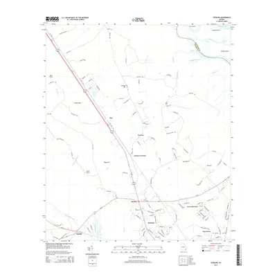
2014 Map of Sterling
USGS Topo · Published 2014About this map
The Altamaha River system dominates the northern landscape of this Glynn County coastal plain, where the South Branch South Altamaha River winds around Lewis Island and Cambers Island. The settlement pattern follows the corridor of Us-341, which connects the communities of Zuta, Pennick, and Frazers Crossing. Local geography is defined by low-lying wetlands and islands, with distinct names like Boggy Gall, Scrub Island, and Rough Island punctuating the terrain.
Find a feature on this map
122 named features on this map. Tap any name to fly to it.
Don’t see what you’re looking for? This feature index may not catch every label — zoom into the map to look around manually.
Map Details
Editions of this 2014 Sterling Map
This is the sole edition of this map. No revisions or reprints were ever made.
Other maps of this area

1918 · Everett City
USGS Topo · 1:62,500

1918 · Bladen
USGS Topo · 1:62,500

1920 · Everett City
USGS Topo · 1:62,500

1921 · Darien
USGS Topo · 1:62,500

1939 · Bladen
USGS Topo · 1:62,500

1944 · Everett City
USGS Topo · 1:62,500

1945 · Brunswick
USGS Topo · 1:62,500

1946 · Brunswick
USGS Topo · 1:250,000

1948 · Brunswick
USGS Topo · 1:250,000
1954 · Ridgeville
USGS Topo · 1:24,000