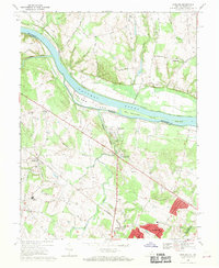
1968 Map of Sterling
USGS Topo · Published 1970About this map
The Potomac River flows past the large Selden Island and Van Deventer Island, marking the border between Loudoun County, Virginia, and Montgomery County, Maryland. Along its northern bank, the historic Chesapeake and Ohio Canal is clearly defined, following the river's bend. To the south, the landscape reflects the rapid suburban transition of the late 1960s. The established community of Sterling Park shows a dense residential grid, while nearby Broad Run Farms maintains a more spread-out character.
Find a feature on this map
45 named features on this map. Tap any name to fly to it.
Don’t see what you’re looking for? This feature index may not catch every label — zoom into the map to look around manually.
Map Details
Editions of this 1968 Sterling Map
4 editions found
Other maps of this area

1884 · Harpers Ferry
USGS Topo · 1:125,000

1890 · Mt. Vernon
USGS Topo · 1:125,000

1891 · Harpers Ferry
USGS Topo · 1:125,000

1891 · Mt. Vernon
USGS Topo · 1:125,000

1893 · Frederick
USGS Topo · 1:125,000

1893 · Harpers Ferry
USGS Topo · 1:125,000

1894 · Warrenton
USGS Topo · 1:125,000

1894 · Frederick
USGS Topo · 1:125,000

1894 · Mt. Vernon
USGS Topo · 1:125,000

1897 · Mt. Vernon
USGS Topo · 1:125,000