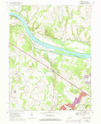
1968 Map of Sterling
USGS Topo · Published 1973About this map
The Potomac River forms a wide natural boundary between Maryland and Virginia on this late 1960s survey, dominated by several large islands such as Selden Island and Van Deventer Island. Along the northern bank, the historic Chesapeake and Ohio Canal and its accompanying Towpath trace the river's edge, reflecting an older era of commerce. In Loudoun County, the landscape is in transition as suburban development expands south of the river. New residential patterns emerge at Sterling Park and Broad Run Farms, while established local landmarks like St Pauls Ch, Guilford Sch, and the Broad Run High Sch anchor the growing communities. The map also captures the path of Broad Run and Sugarland Run as they drain north toward the Potomac, alongside infrastructure like a Pipeline and the Radio Facility.
Find a feature on this map
49 named features on this map. Tap any name to fly to it.
Don’t see what you’re looking for? This feature index may not catch every label — zoom into the map to look around manually.
Map Details
Editions of this 1968 Sterling Map
4 editions found
Other maps of this area

1884 · Harpers Ferry
USGS Topo · 1:125,000

1890 · Mt. Vernon
USGS Topo · 1:125,000

1891 · Harpers Ferry
USGS Topo · 1:125,000

1891 · Mt. Vernon
USGS Topo · 1:125,000

1893 · Frederick
USGS Topo · 1:125,000

1893 · Harpers Ferry
USGS Topo · 1:125,000

1894 · Warrenton
USGS Topo · 1:125,000

1894 · Frederick
USGS Topo · 1:125,000

1894 · Mt. Vernon
USGS Topo · 1:125,000

1897 · Mt. Vernon
USGS Topo · 1:125,000