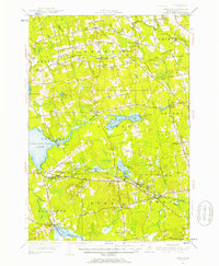
1955 Map of Stetson
USGS Topo · Published 1957About this map
Pleasant Lake and the smaller Etna Pond anchor the center of this mid-century portrait of Penobscot County, Maine. The landscape is a network of small crossroads settlements and agricultural outposts, where town life revolved around landmarks like the Fairgrounds in Exeter Corners and the Town House in Exeter Center. Water-powered industry is still evident through sites like McGregor Mill on the Kenduskeag Stream and French Mill further west.
Find a feature on this map
80 named features on this map. Tap any name to fly to it.
Don’t see what you’re looking for? This feature index may not catch every label — zoom into the map to look around manually.
Map Details
Editions of this 1955 Stetson Map
3 editions found
Other maps of this area

1900 · Bucksport
USGS Topo · 1:62,500

1902 · Bucksport
USGS Topo · 1:62,500

1902 · Bangor
USGS Topo · 1:62,500

1926 · Burnham
USGS Topo · 1:62,500

1930 · Pittsfield
USGS Topo · 1:48,000

1931 · Stetson
USGS Topo · 1:48,000

1932 · Brooks
USGS Topo · 1:62,500

1932 · Dover-Foxcroft
USGS Topo · 1:48,000

1932 · Pittsfield
USGS Topo · 1:62,500

1933 · Boyd Lake
USGS Topo · 1:62,500