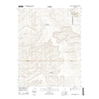
2014 Map of Stevens Canyon North
USGS Topo · Published 2014About this map
The dramatic geological uplift of the Water Pocket Fold dominates this landscape along the border of Garfield and Kane Counties. As part of the Glen Canyon National Recreation Area, the terrain is defined by deep incisions and sharp ridges, most notably Stevens Canyon and the winding course of Grand Gulch. The northeastern corner transitions into Capitol Reef National Park, where the high desert plateau gives way to the monocline's striking rock layers. Small seasonal drainage patterns, such as Millers Cr, cut through the sandstone, illustrating the erosive forces that have shaped this portion of the Colorado Plateau. This survey serves as a precise record of federal land boundaries and topographic relief in a region where natural barriers have historically dictated movement and land use.
Find a feature on this map
12 named features on this map. Tap any name to fly to it.
Don’t see what you’re looking for? This feature index may not catch every label — zoom into the map to look around manually.
Map Details
Editions of this 2014 Stevens Canyon North Map
This is the sole edition of this map. No revisions or reprints were ever made.
Other maps of this area

1886 · Escalante
USGS Topo · 1:250,000

1886 · Henry Mountains
USGS Topo · 1:250,000

1892 · Henry Mountains
USGS Topo · 1:250,000

1953 · Mt Pennell 3 NW
USGS Topo · 1:24,000

1953 · Mt Pennell 3 SW
USGS Topo · 1:24,000

1953 · Circle Cliffs 4 NE
USGS Topo · 1:24,000

1953 · The Rincon
USGS Topo · 1:62,500

1953 · Hall Mesa
USGS Topo · 1:62,500

1953 · Moody Creek
USGS Topo · 1:62,500

1956 · Escalante
USGS Topo · 1:250,000