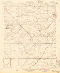
1932 Map of Stevens
USGS Topo · Published 1940About this map
The Kern River landscape west of Bakersfield is defined here by a sophisticated network of irrigation and industrial infrastructure as it appeared in the late 1920s and early 1930s. The Southern Pacific railroad cuts diagonally across the terrain, serving small loading points like Stevens and Strand. This era of development is marked by the heavy presence of water management systems, including the James Canal, Buena Vista Canal, and Pioneer Canal, which transformed this arid stretch of the San Joaquin Valley into productive territory.
Find a feature on this map
15 named features on this map. Tap any name to fly to it.
Don’t see what you’re looking for? This feature index may not catch every label — zoom into the map to look around manually.
Map Details
Editions of this 1932 Stevens Map
3 editions found
Other maps of this area

1906 · Bakersfield
USGS Topo · 1:62,500

1910 · Buena Vista Lake
USGS Topo · 1:125,000

1912 · Buena Vista Lake
USGS Topo · 1:125,000

1929 · Stevens
USGS Topo · 1:31,680

1929 · Coles Levee
USGS Topo · 1:31,680

1929 · Mouth of Kern
USGS Topo · 1:31,680

1930 · Millux
USGS Topo · 1:31,680

1930 · Rosedale
USGS Topo · 1:31,680

1930 · Conner
USGS Topo · 1:31,680

1930 · Oildale
USGS Topo · 1:31,680