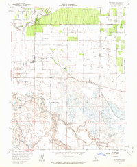
1961 Map of Stevinson
USGS Topo · Published 1962About this map
The confluence of the San Joaquin River and the Merced River dictates the landscape of this 1961 study, where seasonal inundation patterns shape the valley floor. Near the community of Stevinson, the terrain transitions from irrigated agricultural fields along the East Side Irrigation Canal to the complex wetlands of S J Island. This river-bottom country is marked by numerous waterways including Bear Slough, Salt Slough, and Deep Slough, which weave through an area dense with Duck Ponds and designated wildlife spaces like Hatfield State Park.
Find a feature on this map
56 named features on this map. Tap any name to fly to it.
Don’t see what you’re looking for? This feature index may not catch every label — zoom into the map to look around manually.
Map Details
Editions of this 1961 Stevinson Map
3 editions found
Other maps of this area

1916 · Mitchell School
USGS Topo · 1:31,680

1916 · Cressey
USGS Topo · 1:31,680

1917 · Turlock
USGS Topo · 1:31,680

1918 · Arena
USGS Topo · 1:31,680

1918 · Stevinson
USGS Topo · 1:31,680

1918 · Gustine
USGS Topo · 1:31,680

1918 · Turner Ranch
USGS Topo · 1:31,680

1919 · San Luis Ranch
USGS Topo · 1:31,680

1919 · Ingomar
USGS Topo · 1:31,680
1942 · Irwin
USGS Topo · 1:62,500