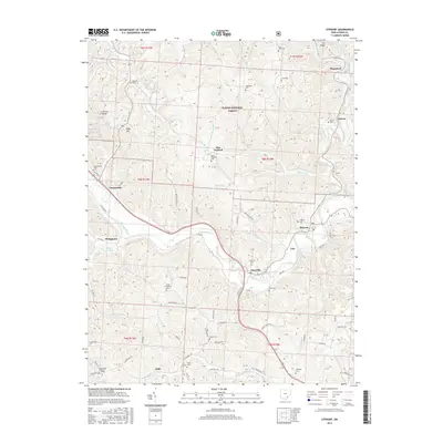
2016 Map of Stewart
USGS Topo · Published 2016About this map
The Hocking River winds through the heart of this Athens County landscape, anchoring a network of small settlements and rural townships. In this 2016 survey, the community of Stewart sits at a prominent bend in the river, flanked by Guysville to the west and the ridge-top hamlet of Cole to the east. The terrain is characterized by steep valleys and narrow ridges, much of which is encompassed by the Wayne National Forest, illustrating the region's transition from early industrial agriculture back toward managed timberland.
Find a feature on this map
112 named features on this map. Tap any name to fly to it.
Don’t see what you’re looking for? This feature index may not catch every label — zoom into the map to look around manually.
Map Details
Editions of this 2016 Stewart Map
This is the sole edition of this map. No revisions or reprints were ever made.
Other maps of this area

1903 · Athens
USGS Topo · 1:62,500

1904 · Chesterhill
USGS Topo · 1:62,500

1905 · Athens
USGS Topo · 1:62,500

1906 · Chesterhill
USGS Topo · 1:62,500

1907 · Pomeroy
USGS Topo · 1:62,500

1907 · Keno
USGS Topo · 1:62,500

1947 · Columbus
USGS Topo · 1:250,000

1949 · Clarksburg
USGS Topo · 1:250,000

1956 · Clarksburg
USGS Topo · 1:250,000
1960 · Alfred
USGS Topo · 1:24,000